DATALOG WITH GUIDANCE
HYDROGRAPHIC SURVEYING SOFTWARE
DATALOG WITH GUIDANCE is an easy-to-use hydrographic data collection software program designed to operate with vessel positioning equipment and depth sounders. It runs on any PC compatible computer which has at least two serial ports. One port brings in position information from either a total station (horizontal distance, vertical angle and slope distance) or GPS (Latitude/Longitude, either DGPS or RTK). The second port is used to bring in depths from any Innerspace sounder or other sounder with NMEA output. Operator interface is via intuitive pop-up windows with all necessary prompts. Left / right guidance is provided for the boat operator and data is logged in ASCII format. The ASCII files are compatible with AutoCAD, Surfer, Intergraph or other terrain modeling processing software.
DATALOG WITH GUIDANCE CONSISTS OF APPROXIMATELY 25 POP-UP SCREENS IN THREE CATEGORIES, SURVEY SET-UP, DATA COLLECTION AND UTILITIES. SIX SCREENS ARE SHOWN BELOW; THE ENTIRE SOFTWARE, FOR DEMO PURPOSES, CAN BE SENT VIA E-MAIL UPON REQUEST.
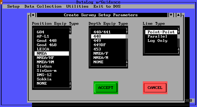
ANY TOTAL STATION WITH RS232 OUTPUT OR GPS WITH NMEA OUTPUT CAN BE USED INCLUDING: TRIMBLE, LEICA, ASHTECH, SOKKIA, TOPCON, GEOTRONICS, ROCKWELL, JAVAD AND LEITZ
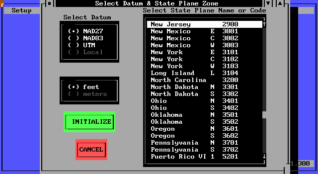
FOUR COORDINATE SYSTEM SELECTIONS ARE AVAILABLE
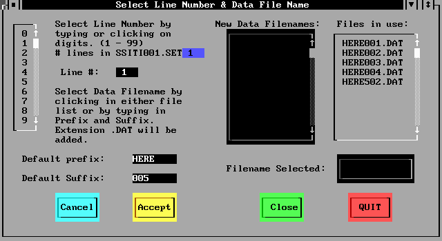
AS MANY AS 60 SURVEY LINES CAN BE LOADED INTO THE SOFTWARE IN AN OFFICE ENVIRONMENT PRIOR TO CONDUCTING THE SURVEY, THEREBY MAKING THE ONBOARD DATA COLLECTION AN EASY TASK
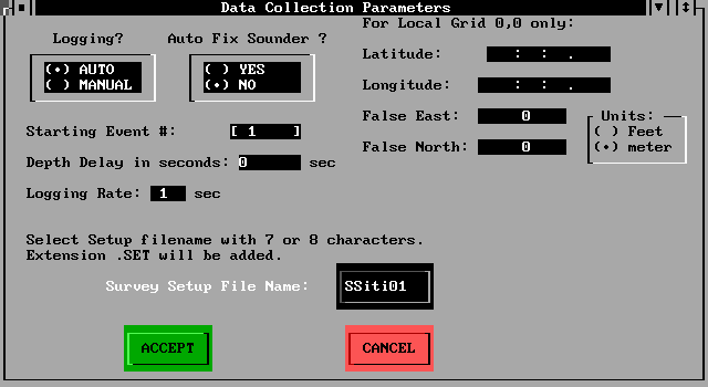
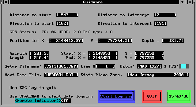
ADDITIONAL SURVEY SET UP PARAMETERS
SCREEN PRESENTATION WHILE PROCEEDING TOWARDS NEXT SURVEY LINE. TWO STYLES OF HELMSMAN DISPLAY ARE AVAILABLE
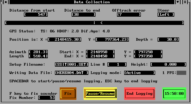
SCREEN PRESENTATION WHILE LOGGING DATA ON SURVEY LINE
OPTIONS: MODEL 603 & 905
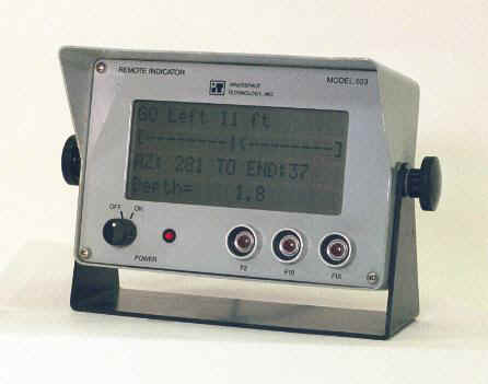
MODEL 603 REMOTE INDICATOR
The 603 Remote Indicator is an accessory to Innerspace’s Datalog With Guidance software and provides steering information for the helmsman, for both navigation guidance and on-line tracking. Guidance information includes distance and bearing to start of line. While on-line, information displayed includes: Line Number, Time, Depth, Distance to End of Line, Distance Off-Line, Speed and Bearing. In addition, an analog-type line shows distance off track by means of proportional arrows. The position and direction of the arrows show which way to steer to stay on line, and the relative distance off line.
The 603 is better than a computer monitor since it is smaller, more rugged and displays only pertinent information needed for steering the survey boat; not the full computer screen as would be with a standard computer monitor. The transflective display allows operation on open boats in direct sunlight.
FEATURES
- 20 CHARACTER x 4 LINE Alpha Numeric LCD with Backlight
- Character Height 3/8 inch
- DC or AC Operation
- Weatherproof Housing and Connectors
- Size 10 in L x 5 in W x 6 in H
Product data sheet is available; contact our sales department
MODEL 905 DATA MULTIPLEXOR
The 905 Data Multiplexor is an accessory to Innerspace’s Datalog With Guidance software. The 905 is installed between the data collection hardware (including depth sounder and positioning) and the data logging computer, thereby allowing a single port computer to be used to collect both position and depth instead of a two port computer which would otherwise be required.
FINAL PRESENTATION
Datalog With Guidance software (DLWG) produces an ASCII X-Y-Z CAD compatible file including point number (X), (Y) and (-Z). The following two plots are final presentations of data collected with DLWG.
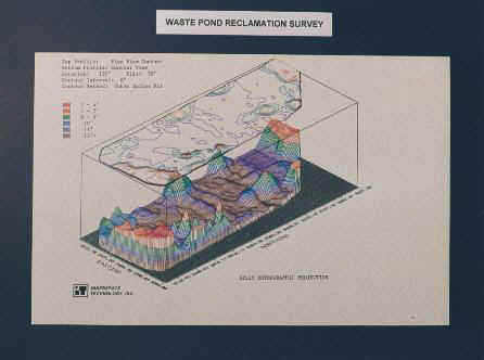
WASTE POND RECLAMATION SURVEY PLOT
Settling pond contour done for chemical company. Data collection equipment used included: Model 449 depth sounder, 453A RF Modems, Total Station and Datalog With Guidance Software. Data was processed using Innerspace and Surfer Software. Other applicable processing software includes: AutoCad, Intergraph, Eagle Point and other terrain modeling packages traditionally used for land surveying plots.
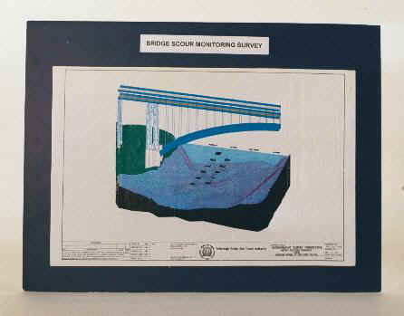
BRIDGE SCOUR MONITORING SURVEY
Survey done for the New Your City Triborough Bridge and Tunnel Authority by Lichtenstein Engineering using Innerspace data collection equipment and software. Equipment included: Total Station and Datalog With Guidance software. Processing and plot done on AutoCad.